
Commissioning a map illustrator
What to expect and how to brief one
Introduction
Commissioning a map illustrator is a little different from ordering a standalone illustrations due to the complexity of the task. Illustrated maps are not only functional, showing routes and landmarks, but also artistic – designed to capture the character and story of a place. Whether for a museum exhibition, a university campus, a heritage site or a brand project, an illustrated map can become both a practical tool and a piece of visual storytelling which capture the imagination of your audience and makes your project relatable.
If you’ve never worked with a map illustrator before, it can be difficult to know what to expect. How much detail should you provide? What does the illustrator need in order to begin? And how long does the process usually take?
In this post, I’ll talk about my own commissioning process from the first conversation to the finished artwork, and offer some tips on how to prepare a clear brief so that you get the best possible result from your project.
Why commission an illustrated map
Illustrated maps offer something that conventional maps rarely do: personality and storytelling. They transform a simple layout of streets, buildings or landscapes into a visual narrative that captures the essence of a place.
For museums and heritage sites, an illustrated map can bring history to life, guiding visitors through exhibitions or historic grounds while highlighting points of interest in a visually engaging way. For universities or campuses, it can make orientation more approachable and memorable, turning a potentially confusing layout into something inviting and easy to navigate.
In short, maps are a great tool to showcase the grounds of your organisation. They offer the perspective of the geographical location to introduce your viewers into what you do and care about.
The Process of Working with a Map Illustrator
Initial discussion
Most projects start with a chat about your needs, most importantly the purpose of the project. If we get this right at the beginning, we can save many hours of back and forth later.
Typical questions you should be able to answer:
- Why do you need this map?
- Who is your audience?
- Where will you use it?
- What are the site-specific locations or stories that you would like to be represented on the map?
- What size do you need it?
- Will it be printed or used digitally?
- Do you need it for promotional or commercial purposes?
All these questions and instrumental to get the basics in place.
Research
During the research phase I gather relevant information about the project. I look at the area which needs to be covered by the map, all the key landmarks and notable points of interest. By spending time familiarising myself with the project, I identify references that I can use and other historical material.
Sketching the layout
Using my findings from the research phase I create a rough layout of the base map and the icons to place on top. I add typography usually in the form of hand-lettering and create a composition that suits your project needs. This is all done in a pencil drawing in a very loose style which is quick to create and easy to change. The sketch is shared with you for feedback where the focus is on the placement of all landmarks, roads, and other elements, in other words, the content. Once the content is accurate, we also discuss the vibe, which should be reflected in the style of the drawings and the composition in general. We tweak this up until everyone is happy.
Creating the illustrations
Once the layout is agreed, I begin to draw the individual elements. This includes features, landmarks, wildlife, lettering and other details. Depending on the complexity of the project, I do sometimes share just the line drawing of the whole map at this stage for feedback.
Finishing touches
Colours are applied, often with a specific limited palette that evokes the places’ natural or cultural vibe. The final touches include detailing and refining.
Artwork delivery
Sending high-res artwork in all agreed formats, which usually include pdf and jpg.
How to brief a map illustrator
When you approach a map illustrator for your project, it’s helpful to clarify the following details:
- Purpose: to attract new visitors, to give out the right vibe to a prospective wedding couple, to provide a fun way to navigate our guests, to educate about a location etc.
- A list of site-specific locations: these are any must-include features
- Clarify style preferences: although you should look extensively at the portfolio of the illustrator of your choice to see if their style would suit your project, there is usually some room for wiggle. For example, you may have a set colour palette that you would like this map to work in (matching your brand) or you might want to have something elegant created while including playful elements too. It is something that you should think about in advance. If you can find examples online, sharing those is one of the best way to clarify and communicate your vision for the project.
Details about deadlines and usage requirements: print or digital, promotional or commercial
Common Questions
How long does it take?
Projects vary widely based on the following factors:
Content-based variables:
- the number of items to be included
- level of detail required
- level of accuracy required
- 2D or 3D view of buildings and sites
Team-based variables:
- number of people involved in the feedback process
How accurate does it need to be?
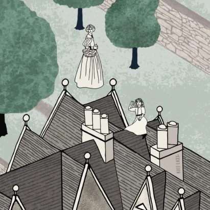
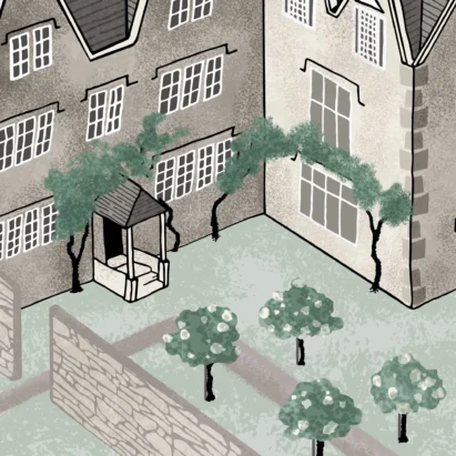
This is completely up to you. My Kelmscott Manor map that was created for the summer residence of William Morris, is an example of a very accurate map with 3D buildings. Both the buildings themselves and the layout of the grounds very closely match reality.
Other maps do not focus on accuracy. An example would be the series of maps I created the the Scottish Field magazine about film locations. While the place names were accurately added, the focus of the map is much more about creating a fun and adventurous vibe that invites readers to go and visit the place in question.
What does it typically cost?
Costs are influenced by the size, level of detail and intended use of the map. It’s more helpful to think in terms of complexity rather than exact figures – a bespoke illustrated map is an investment in both information and artistry. It is not possible to give a specific price or even a starting point because what you are after might be very simple or extremely detailed and complex.
Can revisions be made?
Yes, most illustrators include a revision stage to ensure the map meets your expectations. Clear communication during the initial briefing helps minimise extensive changes later.
Case-study example
To give you a sense of what a project might look like, here’s a recent example:
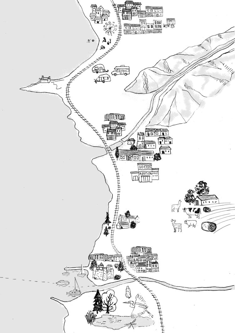
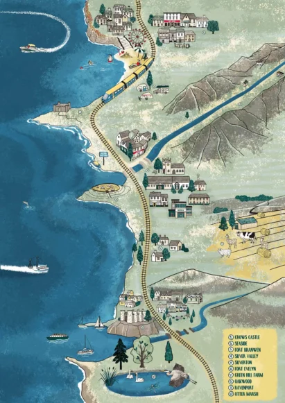
Project: Illustrated map for an educational heritage project about the Welsh coastline
Brief: The client wanted a map that highlighted a range of very specific places in an imaginary map appealing to a primary-school audience.
Process: After initial discussions and reference gathering, sketches were developed and approved. The final illustration included detailed features and hand-lettered labels for a bespoke, timeless feel.
Outcome: The map was used as an online educational resource, helping children understand the way life has changed since the iron ages.
Conclusion
Commissioning an illustrated map needn’t be daunting. By understanding the process, providing a clear brief, and collaborating closely with your illustrator, you can achieve a map that is both functional and visually engaging.
If you’re considering a map illustration for your project – whether for heritage, academic, or commercial purposes – take the first step by reaching out. Together, we can create a bespoke map that brings your location or story to life.

Whether you are a private individual, community project lead, brand director magazine editor, book designer, editor, or curator looking for a map illustrator, get in touch to start to conversation. I look forward to hear about your project!